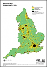
A map showing the areas in England disturbed by the presence of noise and visual intrusion from major infrastructure such as motorways and A roads, urban areas and airports. This map is one of a series of three national maps which show change in the extent of intrusion and the resulting fragmentation of the undisturbed countryside from the early 1960s to the early 1990s to 2007.
For purposes of comparison the maps from each period are based on current regional boundaries drawn from the Ordnance Survey Strategy (2006) dataset.
Intrusion Map: England, early 1960s
 Intrusion map: England 1960s
- Document type: Map
- Author: CPRE and Countryside Commission
- Format: A4, 1pp
- Publication date: September 2007
- Intrusion Map: England, early 1960s