Tranquil places
Developing an Intrusion Map of England
Prepared for CPRE by Land Use Consultants
We have developed a method of mapping areas of intrusion in England. These are areas disturbed by the presence of noise and visual intrusion from major infrastructure such as motorways and A roads, urban areas and airports. The resulting maps show the extent of intrusion in the early 1960s, early 1990s and 2007. This technical report explains how we created our intrusion maps. It gives the distance thresholds which define areas of intrusion and lists the national datasets used. It also includes full statistical tables of areas disturbed and as yet undisturbed by noise and visual intrusion for each time period for England, its regions, counties and unitary authorities.
England's Fragmented Countryside: Ranking of Counties and Unitary Authorities
Intrusion maps table, giving ranking of counties and unitary authorities by % of total area disturbed by noise and visual intrusion.
Give peace a chance
Has planning policy contributed to rural tranquillity?
Tranquillity is a natural resource, and an essential quality of the countryside. It is a much valued aspect of human experience that CPRE has long championed. Although found in many places, it is the countryside that gives us the best chance to experience it. With its broad views, woodlands and heaths, wildlife, the sounds of nature, massive skies, and open water, the rural environment offers us many opportunities to experience deep tranquillity. It enables us to appreciate the beauty and harmony of the natural world. Tranquillity is a central part of why the countryside matters deeply to so many people and the reason many want to spend time there.
In this report CPRE calls on the new Government to take action to value and protect the character of the countryside, which gives people beautiful and tranquil places to enjoy and enriches their lives. We need to make the tranquillity policy that is already in national planning policy more effective. To do that we need improved guidance and an up-to-date evidence base to support tranquillity policy at local and national level.
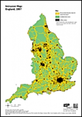
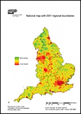
Intrusion Map: England, 2007
For purposes of comparison the maps from each period are based on current regional boundaries drawn from the Ordnance Survey Strategy (2006) dataset.
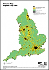
Intrusion Map: England, early 1960s
For purposes of comparison the maps from each period are based on current regional boundaries drawn from the Ordnance Survey Strategy (2006) dataset.
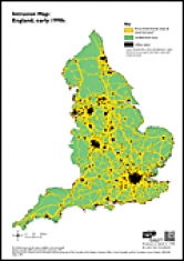
Intrusion Map: England, early 1990s
For purposes of comparison the maps from each period are based on current regional boundaries drawn from the Ordnance Survey Strategy (2006) dataset.
Mapping Tranquillity
Defining and assessing a valuable resource
Places that make us feel tranquil take us away from the stresses and strains of everyday life and help us to relax — but they face a multitude of threats and are shrinking in size. We have developed a new method of mapping tranquil areas which builds on our previous work. This methodology takes into account people's experiences of the countryside and what qualities contribute to a feeling of tranquillity. It also looks at what factors detract from tranquillity — people, landscape and noise are key themes. The resulting tranquillity maps can be used as an important indicator in helping to protect the the countryside. This report explains the research undertaken in the north east of England to develop the new methodology and mapping techniques in two pilot study areas: Northumberland National Park and the West Durham Coalfield.
Saving Tranquil Places
How to protect and promote a vital asset
Report setting out CPRE’s work to measure, and from that map, tranquillity across England: why and how we measured it and what we want policy and decision-makers to do now.
CPRE has also produced regional reports based on this research. To request a regional report, please email Graeme Willis (This email address is being protected from spambots. You need JavaScript enabled to view it.).
Tranquillity Mapping: Developing a robust methodology for planning support
Technical Report on Research in England, January 2008 (revised)
Finding the qualities of places which generate tranquil feelings and protecting those locations and attributes is vital for a country pressured by development.
This report details the research into tranquillity mapping carried out during 2006 by Northumbria University, commissioned by CPRE. It builds on previous methodology led by individual feelings about tranquil places with a simpler quantitative consultation approach, giving a ‘national’ understanding of the concept of tranquillity.